

 " alt="Loading..." title="Loading" />
About The Forgotten Highway
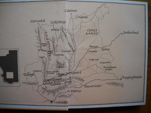
The Forgotten Highway formed part of the old route to the North and was used by explorers such as Burchell and Lichtenstein.
The route to the North played a cardinal role in the development of Ceres as a village. The route ran through Ceres and many transport riders, miners, mail coaches passed through the village and provided the boost for economic development and prosperity.
For more than 200 years, travellers used Karoopoort as a place to stay over before venturing on into the interior. Karoopoort is situated 43 km from Ceres and is presently being farmed
“Between Karoo Poort beyond Ceres and Verlaten Kloof there is a long-forgotten highway which was once part of the great road to the north-east.
It began as the route across the Bokkeveld Karoo used by farmers from the Warme Bokkeveld (Ceres Basin) who, 1750 and 1800, were establishing “leen plaase” and even permanent farms over the Koedoesberg along the foot of the Roggeveld Range. Long before there was a Kimberley, a Fraserburg or even a Beaufort West, the continuation of this old road beyond Verlaten Kloof became the usual route to the Gariep or Orange River, to Kuruman and the Klaarwater Mission and beyond the Litako (Takoon).
The forgotten highway runs from Karoo Poort across Spes Bona (Inverdoorn) beneath the Paardeberg, and takes an arrow flight across the Bokkeveld Karoo to the Hang Rock when the hills begin. This deserted spot had once been an important landmark on this Karoo. Beneath it there is an area of scrub-denuded ground which marks the ancient outspan- place. The forgotten highway leads through hilly country beyond this spot. It passes Yuksfontein where the track crossed the dry and tree-lined Yuks River.
You travelled across Marigold Heights to Windheuvel. From the Windheuvel the old highway sloped down to the valley of the Tanqua and at Vinkelkuil it blends with the modern high road to Verlaten Kloof. Verlaten Kloof or Abandoned Kloof is a great gash in the wall of the Roggeveld Range. Some early and heroic burgher took his waggon through this kloof and led the way for what is now to be the national northen route.” (extract from “Old Cape highways” by Dr EE Mossop)
Reviews for The Forgotten Highway
1 review Reviews of4 out of 5 stars
Accommodation near The Forgotten Highway

Settle - Inn
Avg per night for 2 guests
Die Heks se Huis : Cerridwen
Avg per night for 2 guests
Rogge Cloof
Avg per night for 2 guests
The Artists Cottage
Avg per night for 2 guests
Die Heks se Huis: Hecate
Avg per night for 2 guests
Die Heks se Huis: Artemis
Avg per night for 2 guests
The Forgotten Highway Map
*Distances are shown as the crow flies and not necessarily the actual travelling